Scenic Motorcycle Rides In California
The routes listed along with the bars, restaurants, and tourist points make for some of my favorite motorcycle riding in the state of California.
California is a beautiful state from every aspect, but once you climb upon a motorcycle and get to feel the full experience of this gorgeous state from 2 wheels it is difficult to find a state with more riding diversity.
From the northern redwoods that will put your life into perspective with the massive trees you will roll by on pristine paved roads to the people watching along Venice beach to the deserts of the eastern side of the state and right up to the Sierras.
California is one state that you will want to spend some time and when I say time I mean you want to enjoy this state and have the ability to savor each region and each road to fully squeeze each drop of riding paradise out of this area of the country.
Garberville to Fort Bragg, CA
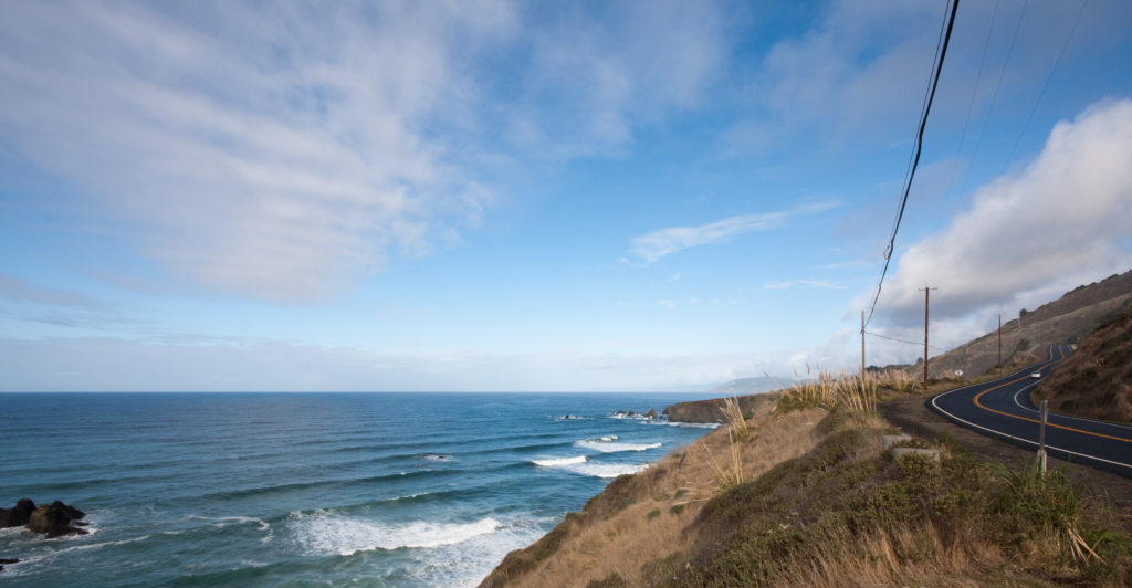
I chose this route as my #1 in California due to the technical street riding, lack of traffic, and scenery. This route also has plenty of classic Americana stops along the way that even for this short ride will add to the enrichment of this route.
It is an out of this world experience and you will feel at times as if you are in Star Wars zooming through Endor on a speeder and as soon as you adapt to that environment you will be thrust out of the forest and into the vast openness of the mighty Pacific Ocean as you absorb the views from cliffsides it is hard to achieve a greater riding experience from every angle over such a short distance.
Tourism Opportunities
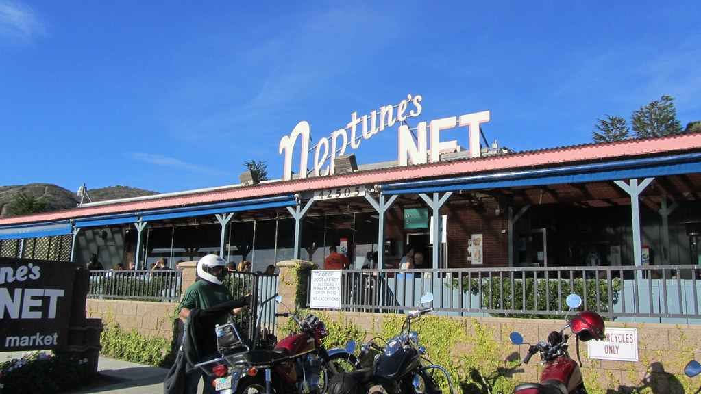
Garberville is a wonderful place to start from as it is a quaint little hidden California town with some great food and wonderful people you will meet who are down to earth and easy to talk with as you share a cold beverage or food with as you compare and contrast tales from the road.
There aren’t a lot of restaurants or stores in Garberville but the two I would recommend are below:
Where To Stay / Camp Along The Route
Both Garberville and Ft. Bragg has numerous hotels and camping, and even though this is a short ride I highly recommend making this trip an overnighter in order to fully absorb the culture of this part of the state and its beauty.
Santa Monica to Oxnard
A quintessential California beach road with exhilarating sweeping corners that introduce a new view of the Pacific as you lean through each turn.
For what one would think of a California dream road to be – this is the one. Riding it early in the morning can be the best time due to low traffic and the ability to taste the salt from the Pacific Ocean as you wind northbound. There are plenty of beaches and overlooks to stop at to really allow yourself to take in the beauty of this part of California.
Tourism Opportunities
Santa Monica is a great starting (or ending) point and you can walk out to the pier or rent bicycles to ride the boardwalk down to Venice Beach which will allow for some outstanding people watching and opportunities to engage in tourist attractions along the way. As you travel north from Santa Monica there is no shortage of quaint restaurants and shops along PCH1 to stop and relax. This is a road that feels as though it’s designed for a leisurely ride in order to fully experience the sights and sounds while on two wheels.
Where to Stay / Camp along the Route
Camping is limited along this route but Point Mugu State Park is a great place where you can beach camp. Hotels are plentiful along this route as backups in both Santa Monica and Oxnard.
Highway 120 Tioga Pass
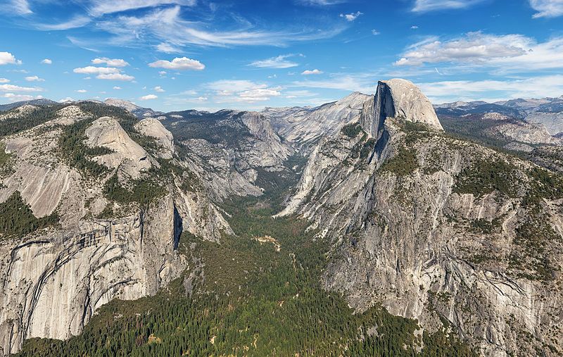
One of the best roads in California hands down. This road actually goes through Yosemite National Park and over some pretty intense switchbacks to Tioga Pass where you will feel as though you are on top of the World, and at almost 10,000 feet that isn’t too far from the truth. There are minimal fuel stops along this way so be prepared and fueled up.
Some incredible scenery as you pass through Yosemite National Park and even more breathtaking as you lean into some of the tightest switchbacks you can ever hope to encounter with serious drop-offs so be sure to not get too caught up in the scenery and maintain focus on the road.
Tourism Opportunities
Although this area of California is not as populated as some of the others there are plenty of places to stop and eat and with Yosemite National Park as the centerpiece of this ride, there is no shortage of beauty and experiences to be had.
Where to Stay / Camp along the Route
There are some really great little inns, hotels, and quaint bed and breakfasts along this route. All the ones I have lodged in have been wonderful experiences and in talking with other riders for recommendations none have disappointed me. Below are 2 of my favorites on each side of the route and camping opportunities within Yosemite.
Cotton Springs Road
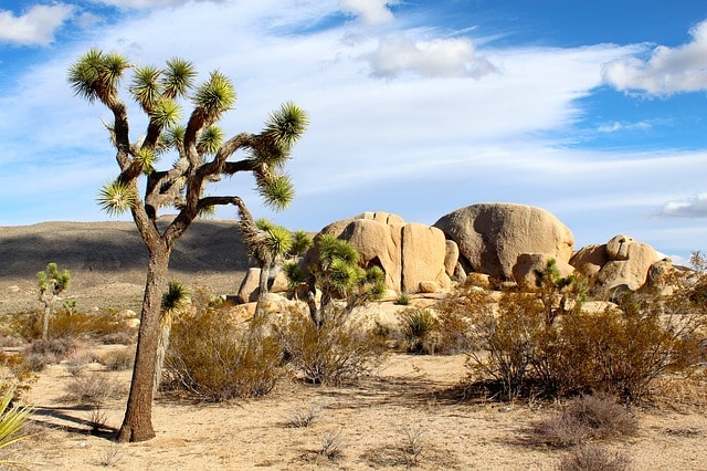
A short but deeply satisfying route that winds through Joshua Tree National Park. No services along this way so be sure you fill your tank either east on I-10 at the Chevron Station or in the town of Joshua Tree (depending on which way you are traveling. Also ensure you have a lot of water and are hydrated due to excessive heat during times of the year.
Beautiful desert and mountain views. In spring there are fields of wildflowers that really show how much life is in the fragile ecosystem. The roads are in excellent condition and encompass fun sweeping corners then will open up with straightaways that provide majestic vistas of the region.
Tourism Opportunities
This is a rather desolate road, which is great for riders looking to just check out of the crowds and embrace riding. As previously stated there are no gas stations in the park so ensure you fill up prior to entering it.
Where to Stay / Camp along the Route
With Joshua Tree being so desolate. This is an incredible camping experience. On a clear night, you can see the stars and planets like nowhere else. The campground tends to fill up so be sure to reserve a campsite prior to your trip if you choose to camp. As far as hotels go, both the town of Twenty Nine Palms and Joshua Tree have numerous hotels that are perfect for unwinding after the ride.
Mulholland Highway
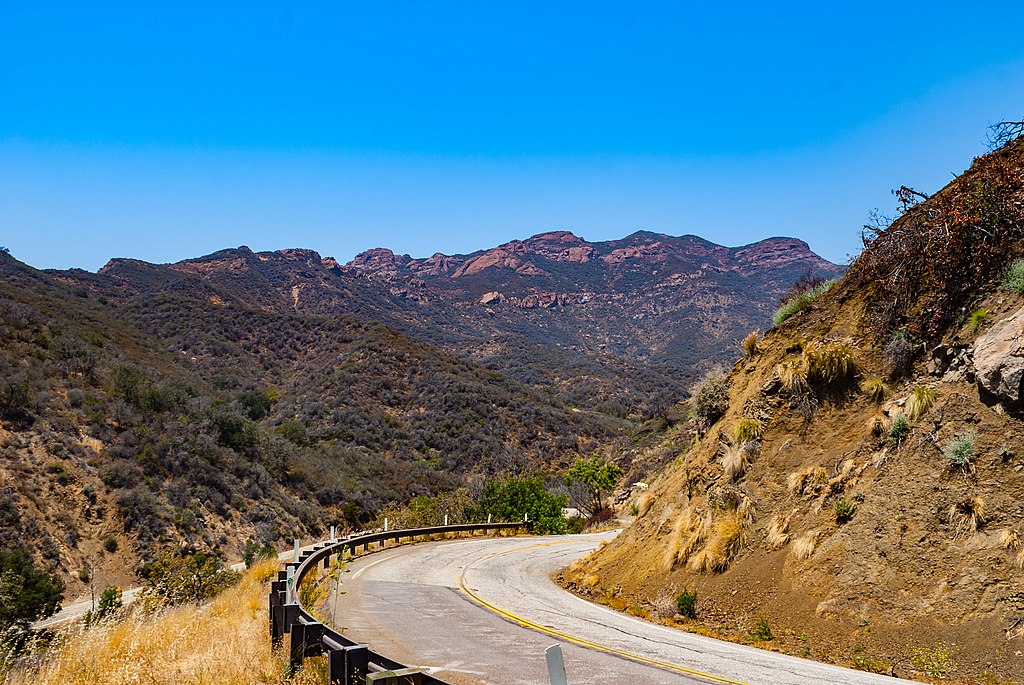
A 50 mile route that is beyond filled with some serious mountain switchbacks. This is an incredibly intense road that to me rivals the Tail of the Dragon in NC. The switchbacks just don’t end as you climb through the Santa Monica Mountains and then get spit out onto highway 1 where the views of the Pacific Ocean welcome you as you regain your breath from a motorcyclists dream ride.
For being in such a metropolis at Los Angeles this road is a real get away without having to travel far. The quality of the road is perfection and something that people from all over the LA area flock to. For this reason, be cautious with your speed as there are several places they set up speed traps, however, quite often fellow riders will park ahead of these speed traps and provide you a warning. If you are looking at getting rid of the chicken strips on your tires this is definitely the road where you can accomplish that.
Tourism Opportunities
This road has minimal places to stop along the way, but with these switchbacks why would you want to stop is a question you will ask yourself along this ride. There is one famous stop that is a must-do as you traverse these mountain roads, The Rock Store. It is a popular place for riders of all types to stop and get a sandwich and a drink. Jay Leno is often seen here talking shop with the riders and being social as we are all a tightly knit community.
Where to Stay / Camp along the Route
With this ride being so close to the city camping options are very minimal. Hotels are numerous on both sides of this ride, however, there are plenty of canyon roads that expand off the main highway that is also worth exploring so even though this main route is a shorter ride you can absolutely make a full day out of this area to really embrace the roads and meet fellow riders along the way.
California 198 – Sequoia
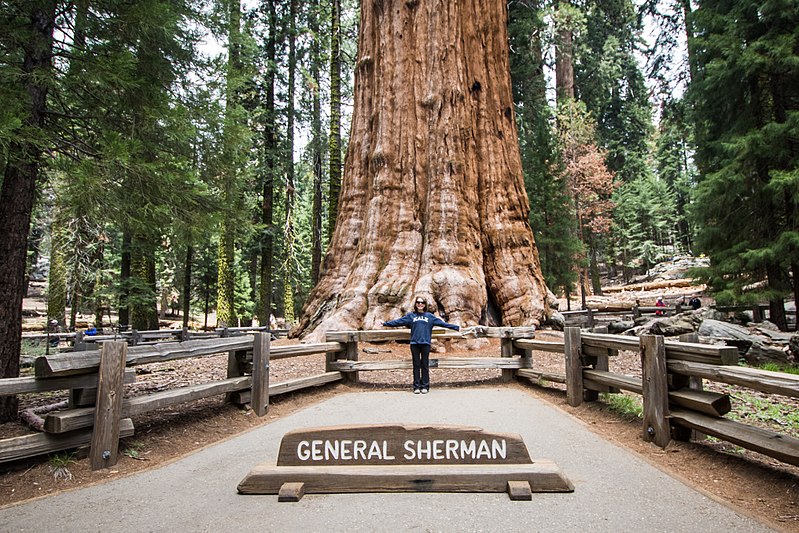
Yes, another mind-blowing road that goes though yet again, another National Park. This route has beautiful mountain switchbacks with no towns and minimal distractions to where you can fully absorb yourself in focusing on the tight corners as you speed next to some of the largest trees on the planet. This is a road that really puts in context how small you as a rider are next to these majestic trees of this National Park.
Although this route can be completed in a day, I would recommend you take two days. The reason for taking this slower is to allow yourself to stop and enjoy the sightseeing along this national park. The road is in excellent condition as you climb the switchbacks to crest the highest point in the park. There are no gas stations along this route so it is imperative that you fill up in either Three Rivers or Hume Lake (75 miles between the two) or outside the northern part of the park near Squaw Valley (90 miles from Three Rivers).
Tourism Opportunities
Since this is a National Park there is plenty to do outside of riding including hiking, sightseeing, cycling, and camping. This is one of my favorite National Parks since it is so stunning but everything is a very short hike to get to. Some of the largest trees in the world reside in this park. The General Sherman Tree is the world’s largest tree and is along this route. There are many other gigantic trees and groups of forest that are awe-inspiring and shouldn’t be missed.
Where to Stay / Camp along the Route
Camping and hotels are limited to what is available in the National Park. Reservations should be made ahead of time as the park can often be booked full and will leave you no other options for 50+ miles for a place to stay.
Ft. Bragg to Bodega Bay, Highway 1
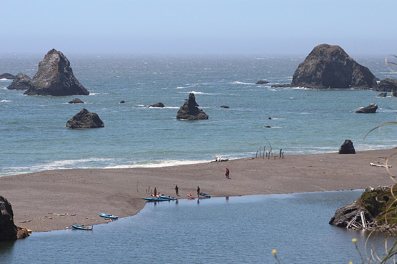
This route can be combined with the Ft. Bragg to Garberville route, but I wanted to ensure they were written on separately as I feel the riding and terrain changes from the previous one to this route. This is Northern California at it’s finest. Pristine ocean views that include lighthouses and beaches for over 100 miles.
Beautiful sweeping corners along the cliffs where you can breathe in the midst of the Pacific Ocean as you blast along one of the most well-known, yet less traveled roads in our country. The road is in great condition and there are plenty of quaint Oceanside towns that have locations to fuel up and allow you to stop in for meals or a beverage along the way. Break up the drive and soak up some sun as you take a breather and bond with other riders who will be having one of the best riding days of their lives – just like you.
Tourism Opportunities
This stretch of Highway 1 has some of the most beautiful and unpopulated beaches in the country. There are several lighthouses that are worth stopping by to visit. Mendocino Headlands State Park is a perfect place to stop and get a short hike in and regain focus for upcoming curves that you will be leaning heavily into as you continue down this magnificent stretch of highway. There are also several small beach communities like Mendocino, Fort Ross, and Gualala you will ride through, any of which make for a great stop for lunch or a stayover if you have the time.
Where to Stay / Camp along the Route
Due to its lack of crowds, this stretch is one of the easier places in my experience to locate campgrounds and hotels in every little beach town are plentiful. As always making reservations ahead of time is recommended to ensure you have a safe place to rest for the evening. I have always had a pleasant experience in these locations and numerous other riders I talk to along my travels have recommended the same spots.
Northern Lake Tahoe Loop
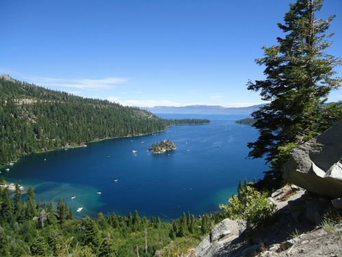
113 miles of diverse riding from open field to challenging switchbacks as you climb the cliffs along beautiful Lake Tahoe and take in some of the most intense roads and views. The road is in excellent condition with much of it newly paved. There are plenty of turnouts for taking photos, which is fortunate because the curves are very sharp and come up quickly so the ability to pull over and take in the views is an added bonus along this trip. The route is not a letdown and both you and your motorcycle will be smiling all day.
This is one of the more picturesque and challenging rides in California. This route provides such a range in diversity, both in the scenery and the road types. You start in Kings Beach where there are rolling meadows and begin to quickly climb to over 9,000 ft. where you will be skirting the edges of cliff sides with some serious switchbacks thrown in for added intensity.
This road is not for beginner riders as the technical cornering along with the beautiful views can be dangerous for a novice to safely navigate, however, for seasoned riders on a clear day the photos from this ride will be the background on your laptop screen.
Tourism Opportunities
This route has plenty of tourism along Lake Tahoe and in Reno, as you loop through the stunning Tahoe National Forest. There are plenty of pullouts along this route to catch your breath and absorb the beauty that is fully surrounding you. As you traverse this loop you will not have to worry about long stretches without gas or shortages of places to stop for lunch and a beverage.
Where to Stay / Camp along the Route
With Tahoe National Forest surrounding you, there are plenty of opportunities for dispersed camping along this ride. There is also an abundance of hotels, both high end and budget as well as state and private campgrounds. In short, there is no need to worry about finding a place to lay your head and recover or prepare for an incredible day of riding here.
Death Valley Ride Highway 190
This road is quite unique from any other; 135 miles of just raw dessert. Ensure you carry extra water to drink although there are gas stations every 35 miles or so but with this terrain being some of the hottest on the planet keeping an extra ½ gallon of water (at least) on you is a wise move.
The road is as desolate as you can get on a motorcycle and the terrain is like something from another planet. Even though the roads are straighter as compared to other rides I have listed, it’s the region and scenery that really make this road jaw dropping. Be very aware of the weather prior to traveling through this area.
If you’ve ever dreamed of driving a motorcycle on Mars this is what it would be like. This road is one that you will never forget due to the dramatic landscape and post-apocalyptic feeling as you roll through the desolate desert of this National Park.
The temperatures are extremely hot so I will mention this again to confirm the weather prior to embarking on this route. Early morning is a perfect time to go if you are traveling east to west to watch the landscape change colors in front of you while you are riding.
Tourism Opportunities
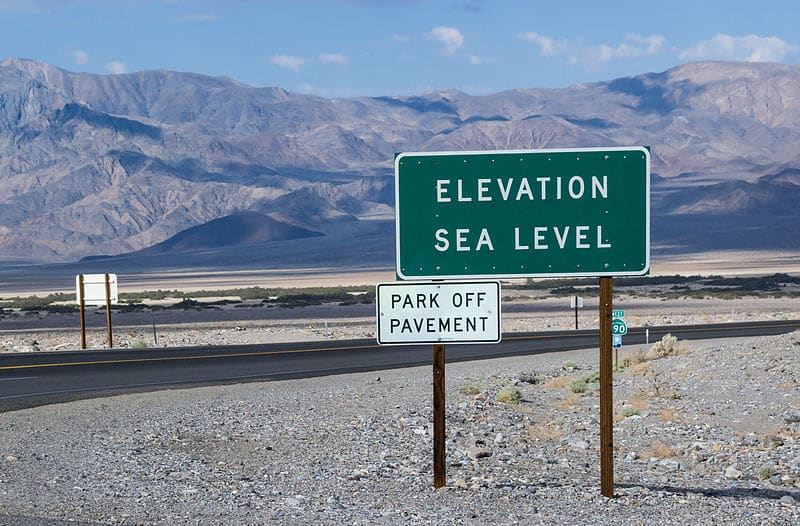
The main attraction of this part of the country is Death Valley National Park. This area is home to the lowest point in the southern 48 with an elevation of -280 ft. As you look into the depths of that point if you turn northward you can see Mt Whitney, which is the highest point in the lower 48, at over 14,000 ft.
In the spring there can be beautiful fields of wildflowers that stretch across the desert, which can make Feb/March one of the best times to go visit this area. This time also provides relief from the extreme heat of this National Park.
Where to Stay / Camp along the Route
This road has only a few places to stop along the way so it is important to ensure your water and fuel levels are topped off at each stop. Even though there are so few places to eat there is plenty of camping along the way during cooler months.
San Juan Capistrone to Lake Elsinore, Rte 74
This is a perfect ride for a Sunday afternoon to wind down from the weekend. Fun switchbacks up through the Ronald W. Caspers Wilderness with some beautiful pullouts to view the lake from above it right before you descend down into the town of Lake Elsinore. This road is ridden by a lot of riders so be aware of that as you travel it and at times there are speed traps.
Beautifully maintained roads where you can really practice cornering on your motorcycle. This road is more of a social route that will allow you to stop and chat with fellow riders and build new friendships. It’s close proximity from LA which makes it perfect to knock this out any day where you have a few spare hours and need some wind therapy.
Tourism Opportunities
Once you leave San Juan Capistrone there is nothing until Lake Elsinore, except for probably one of the coolest motorcycle bars I have ever visited, Hell’s Kitchen Motorsports Bar and Grill. This is a place you have to stop at along this road to meet other riders and get a beverage and a burger. There are also several hikes with waterfalls that are worth stopping by for a break and to stretch out.
Where to Stay / Camp along the Route
Surprisingly for such a short stint of road, there are several wonderful camping opportunities either along the beach or in the hills along Rte. 74. All the campgrounds along this road are very clean and well maintained. These can allow for a weekend getaway that isn’t too far of a ride to get some air and enjoy a nice fire glowing off your motorcycle as you unwind from a week at work.
Last Checkpoint
As you can see there is no shortage of beautiful roads in California. These routes listed along with the bars, restaurants, and tourist points are some of my favorites in the state. The experiences you embrace along these roads are sure to create some of the fondest memories that will stay with you for a lifetime and will enjoy sharing with your fellow riders around campfires. If you found this article useful or would like to share your roads and experiences in California please let us know your favorites so we can work together to expand our skills in this unforgettable state.